On this page
The SG04 site explained
Last reviewed: June 2026
In a nutshell
SG04 is a stretch of open Green Belt fields of around 60 hectares on the southern edge of Kenilworth, either side of Rouncil Lane. The plan proposes roughly 750 new homes here. The fields matter because of the setting of Kenilworth Castle, the open land that keeps Kenilworth and Leek Wootton apart, pressure on local roads and services, and wildlife. At the last consultation, far more people objected than supported it — and so did the Town Council, a neighbouring parish council and Historic England.
New to this? What is the Green Belt?
In short, it is land kept permanently open to stop towns sprawling and merging into one another, which can only be built on in “exceptional circumstances.” These SG04 fields are Green Belt. Our planning guide explains it more fully — the Green Belt's five purposes and what “exceptional circumstances” means: What is the Green Belt? →
What and where is SG04?
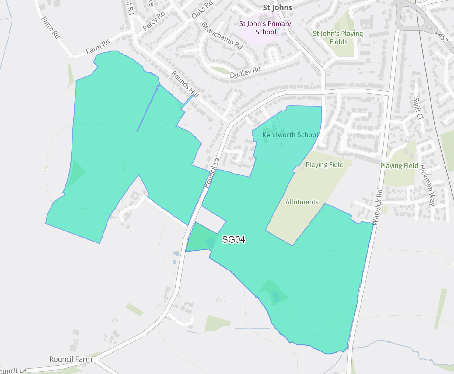
“SG04” is the reference the councils gave to a group of fields put forward as a possible “strategic growth location” south of Kenilworth. It covers around 60 hectares either side of Rouncil Lane, in the area behind Rouncil Lane, Sovereign Close and Rounds Hill. In the draft Regulation 19 plan the site is renamed KEN.1 – South of Kenilworth and given a capacity of 751 homes — so it is fair to describe it as a development of about 750 houses.[1]
Almost all of this land is currently Green Belt, so building here would mean taking it out of the Green Belt through the Local Plan — something the councils can only do if they can prove strong justification. One part is different, and it causes some confusion: the former Kenilworth sixth-form site on Rouncil Lane sits within the SG04 boundary but is not Green Belt (much of it is playing fields), and it was already earmarked for housing under the previous Warwick District Local Plan, after the school moved to Southcrest Farm.[6] So while SG04 as a whole is a new strategic allocation — not carried forward from the old plan — it does absorb that one already-allocated parcel.
Why these fields matter
For all the disruption it would cause, SG04 delivers relatively few homes: its 751 houses are only about 2% of the roughly 36,300 new homes the plan needs to find.[1] Many felt that modest return does not justify the harm. The main concerns are these.
Kenilworth Castle and its setting
Part of the area is historically linked to the castle's former deer park. Historic England — the government's heritage adviser — lodged a potential objection. It said development would harm the significance of Kenilworth Castle, which is a Scheduled Monument — the highest level of protection in England, reserved for archaeological sites of national importance, and a status that carries even greater weight than the castle's Grade I listing — set within a Grade II* Registered Park and Garden.[7] It recommended a Heritage Impact Assessment before any allocation, and said it would prefer the site not to be carried forward in its current form.[2]
“Development would harm the significance of Kenilworth Castle, as the site includes part of the deer park… that contributes to the significance of the castle… They would prefer this [growth location] not to be carried forward into the Reg 19 Plan in its current form and for the areas that contribute to the significance of Kenilworth Castle to be removed.”
Historic England, recorded in the SWLP Consultation Statement, February 2026
Keeping Kenilworth and Leek Wootton apart
The fields help keep Kenilworth and the village of Leek Wootton separate. Objectors argued the land meets all five of the Green Belt's purposes, and that losing it would blur the boundary between settlements and risk Kenilworth, Leamington and Warwick gradually growing together.[2]
Roads, drainage and services
Rouncil Lane — the road intended to provide the main access to the new homes — is a narrow country lane. The transport evidence assumes a substantial new road and junctions would be needed to serve the site.[3] Residents have also repeatedly raised concerns about GP and school capacity and longstanding drainage and sewage problems.
Wildlife and landscape
The fields, hedgerows and trees support local wildlife and form part of the historic Forest of Arden landscape valued across the town. The site also includes productive Grade 2 agricultural land, whose loss would be permanent.[2]
Who has objected
At the Preferred Options consultation in 2025, SG04 drew a strongly negative response: of 269 comments, around 219 objected and only about 32 supported it.[2] Those objecting included:
- Kenilworth Town Council, which said there were no exceptional circumstances to justify releasing the Green Belt here.[4]
- Leek Wootton & Guy's Cliffe Parish Council, which objected to the loss of Green Belt and the buffer between the village and Kenilworth.[5]
- Historic England, on the grounds of harm to the setting of Kenilworth Castle.[2]
What you can do
- Respond to the consultation before it closes on Tuesday 8 September 2026 — this is the last public stage before the inspector.
- Sign the petition and ask friends, family and neighbours to do the same.
- Spread the word — follow and share the campaign on social media.
How to respond to the consultation →
Sources
- Site capacity (KEN.1 – South of Kenilworth, 751 homes) and SG04's small share of the housing requirement: South Warwickshire Local Plan Regulation 19 report to the Joint Cabinet Committee, 28 May 2026 (report PDF), and the parish and town council briefing, May 2026 (PDF).
- Historic England's objection, and the breakdown of representations on SG04, are recorded in the councils' South Warwickshire Local Plan Consultation Statement (the official summary of Preferred Options responses; see the SG04 section, pp. 56–59). Consultation Statement (PDF). Individual representations can also be searched on the SWLP consultation portal.
- Strategic transport testing for the South Warwickshire Local Plan, Warwickshire County Council, 2026. SWLP technical evidence
- Kenilworth Town Council — South Warwickshire Local Plan. kenilworth-tc.gov.uk
- Leek Wootton & Guy's Cliffe Parish Council — SWLP Preferred Options consultation. leekwoottonandguyscliffeparish.gov.uk
- The former Kenilworth sixth-form site (Rouncil Lane) was allocated for housing under the adopted Warwick District Local Plan after the school relocated to Southcrest Farm. Warwick District Council. warwickdc.gov.uk
- Kenilworth Castle's heritage designations — Scheduled Monument and Grade I listed building — on the National Heritage List for England, Historic England. Scheduled Monument (1014041); Grade I listing (1035327).